Tuesday 10 July 2018

The End, for Now

When I started out on this bike trip, it was my intention to end in St. John’s, Newfoundland. Due to a death in my family, I have decided to finish my trip in Halifax instead of carrying on east. Newfoundland isn’t going anywhere, and I can always come back to Halifax and continue on for the final stretch of this trip at some point in the future. 

Though I am ending my trip earlier than I originally planned, I am still really proud of how far I’ve come over the past five and a half weeks. I have biked 2,989 km since the start of my trip and climbed 18,890 m in elevation. While I knew this trip would challenge me physically, I didn’t realize how mentally challenging it would be. From waking up in the middle of the night freezing and wet in my tent, to finding myself on top of a mountain at a dead end road with no cell signal and little water, there were times that I felt unsure about what I had gotten myself into. But the warm and friendly people I have met along the way and the amazing landscapes I’ve seen have made this experience all worth it. I wanted to experience more of Canada, and that’s exactly what I did. 

I would like to thank everyone who welcomed me into their homes along the way, fed me, offered me rides when my bike broke down, gave me advice, or contributed in other ways to this amazing experience, including:
Daniel (Cornwall)
Deb (Bainsville)
Emily, Ryan, and Evan (Montreal)
Marc and Laurie (Quebec)
Dénis and your family (l’Île d’Orleans)
Tracy and Michel and your family (Fredericton)
Maryanne (Shepody Mountain)
Lisa and your family (Fundy)
Mat (Moncton)
Heather and Joe (Murray Beach)
Nathan (New Glasgow)
Alanna and Jim (Montague)
Richard, Genevieve, and Justin (Caribou-Munroes)
Amy and Bruce (Truro)
Nevin (Gaspereau)
Thor, Heather, and Magnus (Halifax)

And Jess, Zac, Jacob, and Maw for the moral support along the way. And to my parents, who despite not being the most thrilled when I told them about my plans, have been very supportive throughout this whole trip. 

This won’t be the last of my pedalling! 🚴🏽‍♀️

Sunday 8 July 2018

Days 38-39: The Ovens

From Halifax I decided to do a round trip to The Ovens, which is just south of Lunenberg. Heather had told me about The Ovens, where there are these caves on the ocean that you can hike around and camp at. So I set off on Friday morning towards Lunenberg. 


Leaving Halifax was confusing, as the signage in Nova Scotia is very poor. So after biking on a terrifying road with cars speeding past me, missing my exit, and crossing over a 4 lane highway to turn around, I finally got on the road heading in the right direction. I was just passing through suburbs for the first 25 km, until I reached Head of Saint Margarets Bay. From there, the road followed along the coast, so I got some really nice views as I went through the small communities along St. Margarets Bay. I passed by a few beaches in Queensland that were packed because of the nice weather. The road then just went through a bit of nothingness while I continued on until East River, which had a really pretty picnic park right in the water where I had lunch. 


From East River, the road started to get pretty hilly as it followed the shoreline of the Mahone Bay. It was pretty hot and the constant up and down was exhausting. By the time I got to Mahone Bay, I had already gone 100 km and had about 25 km to go. I saw a sign for the microbrewery Saltbox as I approached Mahone Bay, which I figured would be a good spot for a break. So I just pushed myself for those final 3 km by telling myself: 10 minutes to cold beer!


I sat in the shade at Saltbox and was still sweating so much. It was 5:30 PM and still somehow 35 degrees. I’ve been told that this heat is very unusual for Nova Scotia, but it’s been unrelentless. Saltbox had a lobster beer, which, as much as I like both those things, initially sounded pretty gross to me. But they let me try it, and it was actually delicious, so I ordered one of them. It was so nice to sit down and relax with a cold beer, but eventually I had to will myself to get up and continue onto The Ovens. 


I had two options, to either continue along the shoreline, or to cut straight down. I chose cutting down, as I’d save about 5 km, and then realized I made a terrible decision, as the road was full of extremely steep hills. I was running low on energy as I approached a monstrous looking hill, but there was an intersection just before it. I was really hoping that intersection would be my turnoff, as my legs did not have much left in them for yet another huge climb. Thankfully, as I got closer, I saw that it was my turnoff, so I was spared at least that one big hill. 


After that it was pretty flat, winding along the coast, passing cottages, until finally I got to the turnoff for The Ovens, and then just had 1 km of an unpaved bumpy road to reach the campground. Once I was there, I took advantage of the pool at the campground and had a dip to cool off. I pitched my tent looking out over the water and collapsed with exhaustion once I was done dinner after such a long day. 


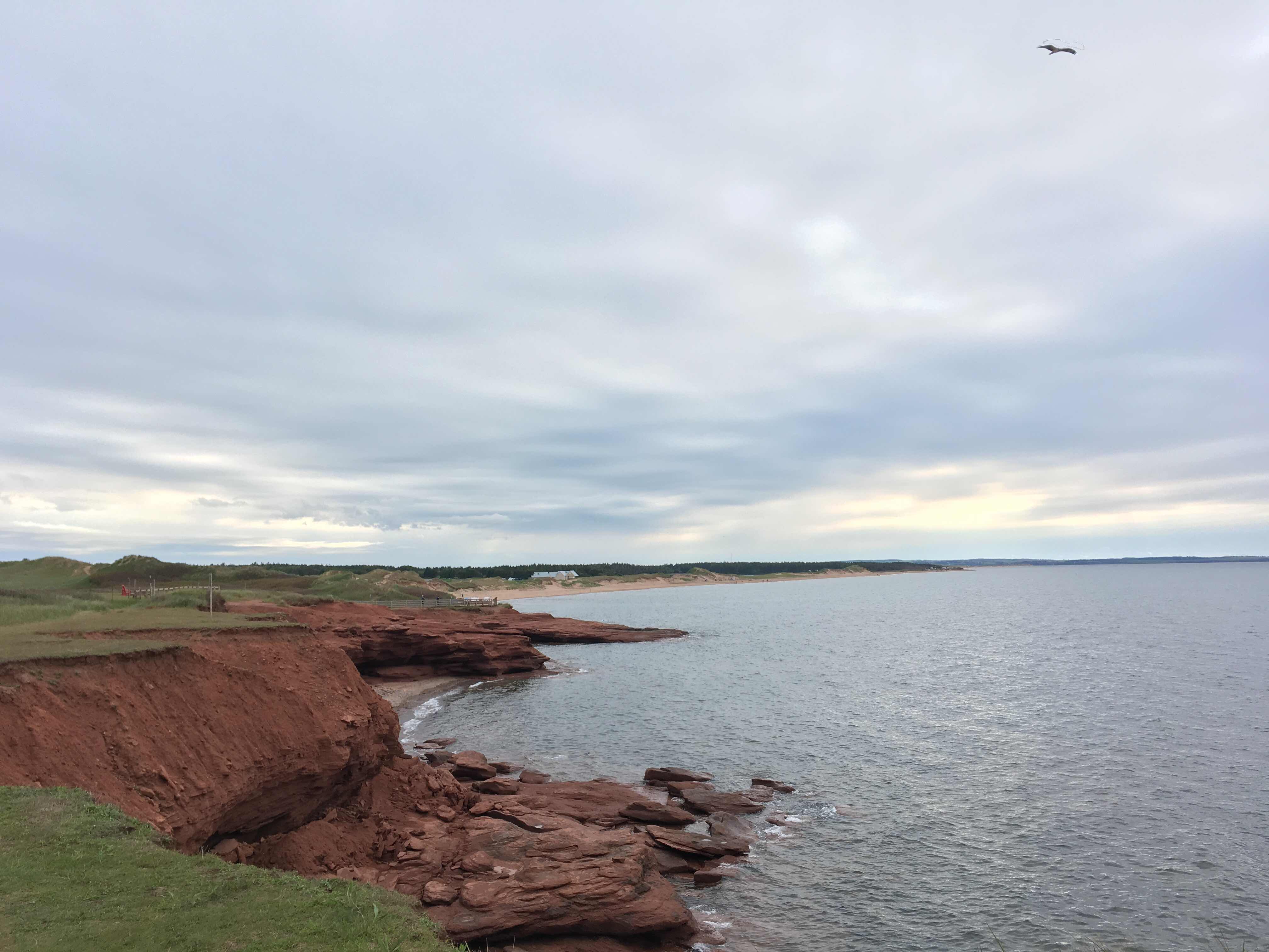
The next morning, I had breakfast by the water and then went over to hike the caves. The town was built following the discovery of gold on this beach in 1861. The gold rush only lasted a few years though, and by 1867, the town had all but been deserted. You could walk down to some of the caves, and hear the waves crashing inside them, which was pretty cool. As I was walking along the caves, I saw the Bluenose II sailing just off the shore.


After the caves, I packed up camp and set off towards Lunenberg. The city is a UNESCO heritage site for being the best preserved British colonial settlement in North America. The houses there are all painted different colours which was cute. When I got down by the water, the Bluenose II was back in the harbour, so I saw it close up. Thor and Heather were telling me though that it’s really like the Bluenose III. Apparently the 2nd version was pretty old and dilapidated and needed to be replaced, but the government was only willing to provide funding to restore it, rather than replace it. So they pretty much rebuilt it from scratch, reusing a couple small pieces of the original skeleton, and are still calling it Bluenose II. I also saw the oldest salt boat in the country, which is a boat where they preserve the fish with salt immediately while on board. So it was a very historical morning. 


There was a bike trail that ran almost parallel to the road I had been on when I came, that was an old railroad track, so it was quite flat. I had avoided it when coming, as it wasn’t paved, but after all the hills in the area, I figured I’d hop onto it at least until East River. When I came out of the trail in Chester, it started to rain, and there was a small shop and museum there that had been a former railway station. I went in and the friendly women working there let me eat my lunch inside to get out of the rain. When I was ready to go, I geared up, and went out to brave the rain. Just before leaving I ran into a couple outside the station that I had passed earlier on in the trail. I started chatting with them and they told me they were from Truro. When I mentioned that I had just been there and stayed with the parents of a friend from Truro, she asked me who my friend was. I told her, and it turns out she worked at the high school my friend went to and knew him. So yet another small world connection on this bike trip. 


I hopped back on the trail and continued on in the rain until East River. From there I got back on the road, as the worst of the hills were over, and I can get more momentum going when I’m on a paved road. It was a pretty miserable ride back from there, as it was just pouring. My raincoat was quickly soaked through, and I could feel puddles in my shoes everytime I pedalled down. When I finally got back to my cousin’s place in Halifax, I was really glad to be able to jump into a hot shower and sleep in a real bed, rather than trying to pitch a tent in the pouring rain. I’m happy I went out to Lunenberg and The Ovens, but it was pretty far in each direction—coming back was my longest day yet. 

Halifax—The Ovens
Distance: 124 km
Elevation: 1,175 m

The Ovens—Halifax
Distance: 129 km
Elevation: 1,102 m

Thursday 5 July 2018

Days 36-37: Halifax

This was my first time in Halifax, so it’s been nice to take a couple days exploring the city. Tuesday I was happy to sleep in a bit and do some laundry before heading downtown. First I went to the Africville museum, which tells the history of the former community of Africville. It was a black community in the north of Halifax, and despite the residents paying taxes, they didn’t receive any services, and it was viewed by many outsiders as a slum. City officials first tried to drive residents out by installing a dump, a jail, and an infectious disease hospital in their neighbourhood. When that didn’t work, they came in the night and tore down the church, the heart of the community, and then evicted the residents. This history was largely ignored/covered up by the city of Halifax until 2010, when finally the city issued an official policy to the former residents and their descendants. They have now rebuilt the church and turned it into a museum about the history of the community. 


After that, I headed down to my cousin’s virtual reality cafe, Nearby Planet, and tried out VR for the first time. I’m not a huge gamer, so I didn’t really know what to expect, but it was super cool! It was crazy how realistic it seemed with the goggles on. He also showed me some of the VR videos he’s made which was pretty cool. 

I then headed downtown and walked upto the Citadel to get a view of the city, before going down to the boardwalk to walk along the water. The boardwalk was really nice, if a bit touristy, and had a bunch of informational panels about the Halifax Explosion and the history of seafaring in the province. I finally meandered my way down to Pier 21, where the Canadian Museum of Immigration is, but it was closing soon, so I didn’t go in. Once I started heading back towards Nearby Planet, I saw a bunch of historical buildings and then a bunch of microbreweries. 


I came back to Pier 21 this morning and spent a few hours there. They had a temporary exhibit on refugees, which I thought was done really well. They had it organized thematically, rather than chronologically, so there was content about the Nazis and the Pinochet era next to content on the Syrian refugee crisis, which I thought was effective at showing the parallels between historical and current day events. Upstairs they had two permanent exhibits, one on the history of Pier 21 itself, and one on the history of immigration both in Canada and globally. I spent the whole morning there and thought the exhibits were really well done and balanced in their presentations. 


There is a farmers market next to Pier 21, so I went in there to grab lunch afterwards. Donairs are the official food of Halifax, so I figured I should try one. They’re similar to a shawarma, but the meat is like made into meatloaf first and then sliced, and instead of tahini they have donair sauce, which consists of condensed milk, vinegar, and sugar. It was disgusting. The meat was a really weird texture, and the sauce was so sweet. I really don’t understand the appeal; I would take a falafel or shawarma over that any day. 

After recovering from my lunch mishap, Thor took me over to meet some of his friends at a yacht club who took me sailing! We went out for a couple hours along the south arm, and saw the weekly race put on by one of the clubs. The weather was perfect, and it was so nice to be out on the water again—Matt, the skipper, even let me steer for a bit!


Overall my time in Halifax so far has just been great. I hadn’t seen Heather and Thor in a long time, so it’s been nice hanging out with them and exploring the city along the way. Heather has camped all over the province, so she has been telling me places in the area that I should check out while I’m here. So on her recommendation, I’ll be heading to The Ovens in Lunenberg tomorrow. 

Tuesday 3 July 2018

Day 35: Gaspereau — Halifax

I could not get moving this morning. After sleeping in, I had a very slow start, and didn’t finish packing up until about 11. Once I hit the road, I had to head back to Windsor before continuing onto Halifax. I stopped at the Tims there for a snack and to use the wifi, because it turns out downloading different navigational apps really ate up my data and I’m almost at my limit. While I was there, a man on the patio started chatting with me and asking all about my trip. He thought what I’m doing is so cool, but was surprised I was out biking on such a hot day (I think it was the high 30s with the humidex). I have to say, as much as I normally love the heat, I did find biking all day in this heat to be a bit insufferable, but I’d rather take the heat than the cold any day. 

From Windsor I took the highway 1 which cuts straight down to the south shore of the province. And along the route I had to pass over Mount Uniacke. It was nowhere near as steep as the mountain I had to climb to get to Cape Split, but it did seem never ending. At least I was getting some nice views, but the view of forests gets old pretty quickly, so once I reached Lakelands, at the top of the mountain, I was seriously happy to see something other than trees. It was really pretty up there, and it looked like a lot of people had cottages around the various lakes. I was tempted to go cool off in one, but it seemed the access to all the lakes was through private property. Also, since I had such a late start to the day, I figured I should keep going to Halifax. 

I stopped in the town of Mount Uniacke to eat and was texting my cousin who I’m staying with in Halifax.  He scared me into thinking I had another mountain to climb after Uniacke, but that didn’t end up being the case (he thought I was on a different highway), so at least I just had to cross over the one mountain today. 

I have come to realize over the past few days though that Nova Scotian drivers are terrible. There’s not a shoulder on a significant number of the roads here, but I was staying on the old highway, which runs parallel to the new multi-lane highway, so I feel like if drivers are in a huge rush, they should just go on the big highway instead of ripping past cyclists on the only road that we can be on. It’s like the drivers here never got the memo that they’re required to give cyclists a one metre berth when passing. All the other provinces I’ve been in the drivers have generally been very considerate towards me, and then the Nova Scotians just seem to get road rage anytime they have to share the road with a slower vehicle. Like some of them squeeze past me so close I could probably touch them, rather than waiting the 10 extra seconds for oncoming cars to pass and then go around. I’ve seen cyclists in Toronto riding around with pool noddles strapped on their back rack to remind cars how much distance they need to give while passing. After today’s ride, I want to get a noodle that extends 90 cm out from my bike with a razor blade on the end, so the next time a car tries to dangerously squeeze past me, they’ll fuck up their car in the process. 

Once I started getting close to Halifax I recognized the generic suburbia that I have to pass through to get to most large cities...the big box stores, the multi-lane roads with no cycling infrastructure and drivers who are seemingly shocked to see anyone outside of a car, the sub-developments full of cookie-cutter houses, the soulessness... I had to pass through that for a solid 90 minutes before reaching Halifax proper. Finally I made it to my cousin’s neighbourhood. All that stood between me and his house was a terrifying multi-lane roundabout, and a really steep hill. It seems as though many of my days end with steep hills, which feel ten times worse than they really are when they come after the 100 km mark. But finally I made it to Thor and Heather’s place, where they welcomed me with a bbq, beer, and a real bed indoors. I’m going to spend a few days exploring the area here, and enjoy being with family and a place to sleep that actually has walls. 

Total distance: 106 km
Total elevation: 1,166 m

Monday 2 July 2018

Day 34: Cape Split

I did a day trip today from Gaspereau which was great, because I got to leave all my gear behind and ride my bike without being fully loaded. The whole reason I came to Gaspereau in the first place is because my friend in Toronto, who’s originally from Wolfville, had said that the Cape Split hike was amazing, and that I should definitely do it while in Nova Scotia. 

So before I left, I took just the essentials, threw them into a backpack, and strapped it onto my back rack. To get from Gaspereau to Wolfville I had to go over a ridge, but Nevin had warned me that it was nothing compared to the ascent I would have to do closer to Scots Bay. 


I didn’t see much of Wolfville, as I biked straight to the bike trail on the north side of the town which took me all the way to the highway I needed to take. From there I went through a few different towns as I approached the ominous sounding town “The Lookoff.” And then the climb began. It was 30 degrees and this ascent was so steep and just kept going and going. Usually with these steep climbs there are at least some flat bits to temper the incline, but with this, it was turn after turn after turn of just going straight up. I was really happy I didn’t have a loaded up bike at this point. 

As I was going up, I was thinking that Rick never mentioned this mountain to me when he told me about Scots Bay. But when I finally got to the top and saw the view, I realized that it was so worth the climb. You could see over all the towns below, as well as into the Minas Basin, which is part of the Bay of Fundy. And there was an ice cream shop at the top! At this point in my trip, I have convinced myself that daily ice cream is part of a healthy and balanced diet...I might need to reassess that when my trip is over, but I definitely got my fill of ice cream at the top after that climb. 


After climbing that steep mountain though, I had to go back down the other side to get to the trailhead. Which normally is the best reward after a hard climb, but knowing I had to go up and back down that mountain again to get back to Gaspereau was a little daunting. I finally got to Scots Bay, where the trailhead for Cape Split is, and already the view along the shore was beautiful. 

The signage welcoming you to the park said that the hike was about 8 km in each direction and would take 4-5 hours round trip. It was already 1:30, and I still had to bike back to Gaspereau at the end of the day, so I was a little nervous for timing, but figured even if I had to bike back late, this is the whole reason I came to this region in the first place. There were a fair number of people there, I guess because of the long weekend, but a lot of them just came and saw the view at the trailhead and then left, discouraged by the posted length of the hike. 


Once I got started, I realized it was a fairly easy walk. It was through the forest, which was nice, but nothing out of this world. I passed a fair number of people, some that were even taking breaks to rest even though it was a mostly flat walk that was under 10 km in each direction, with a shade cover. So this is when I started to realize it wasn’t going to take me 4-5 hours to complete the hike. 


I had started on the hike at 1:40, and by 3 I reached the end, which opened out onto this incredible cliff top point on the Bay of Fundy. We were so high up with a few rock formations just separated from where we could walk to, which were covered with birds, in front of a backdrop of the vast Bay of Fundy. It was pretty awesome. 

I stayed at the point for a bit, had a snack, and took a bunch of photos, before heading back. When I got back out to the other side, I saw that the round trip had only taken me two and a half hours (excluding the time I spent at the cliffs), so I feel like they should adjust their signs to be relevant to more than just the least fit person on the planet. 


Once I was ready to head back, I was trying to psych myself up for the mountain climb, and then when I got going, I realized it was not bad at all. Whereas the other side had been a super steep climb, this side had a mix of climbs and descents to get up, so I had momentum to get me up half the ascents. I was feeling fine by the time I got to the top, but figured I should probably get a 2nd ice cream now that I was up there. The girl working at the ice cream shop also refilled my water for me. And now that I was at the top of the mountain, I realized it would be super easy to get back.


I sailed down the mountain, reaching speeds of 45+ km/hr which felt awesome, and ripped through the community of Canning. Once I got to Wolfville, I came up off the bike path I was on a little earlier so I could actually see a bit of the town. The town itself only has about 3,500 permanent residents, but it doubles in size during the school year with Acadia there. For a small town though, it has a lot going on. There were a bunch of cute little shops and cafes and pubs with patios. I guess because it’s a hub for the surrounding communities, and also there are so many tourists in the summer because of the wineries, they must support the economy quite a bit. 


After Wolfville, I was only 5 km from Gaspereau, and the little ridge I had to cross over (less than 100 m climb) seemed effortless after going over the mountain twice today. Once I got back and made dinner, Nevin invited me to join him and some friends to watch fireworks for Canada Day. They came and picked me up and took me to a neighbouring town to meet up with a few more people. Once we were parked, we started heading towards the park where the fireworks would be. Just as we got to the park, a few fireworks went off, so we thought they were warning shots for the start of the show. But then they just kept going, putting off an entire arsenal of fireworks over the course of just a few minutes. It looked great while it was happening, but it was super short...I don’t know if they accidentally ignited them all at once or if that was the town’s intention, but it was a little disappointing how quickly they ended. We just ended up hanging out at one of their friends’ places for a bit before heading back to Gaspereau. Despite the fireworks being a bit of a letdown, I saw some pretty spectacular views today, so I wasn’t too bummed out about it, and I enjoyed hanging out with Nevin and his friends. Cape Split was such a great recommendation—I’m glad I made the detour. 

Total distance: 81 km
Total elevation: 988 m

Sunday 1 July 2018

Day 33: Truro — Gaspereau

Today was my longest day I’ve done yet! I set off from Truro towards Wolfville in the morning, and it was HOT. By the time I got to South Maitland, about 25 km in, I was ready for a break. I had just passed over a gorgeous river, and I could see that there was an old bridge that had been turned into a lookout just next to the bridge I had gone on, so I pulled over to take a look. There was a small interpretation centre there, and it turned out to be one of the viewing spots of the tidal bore and the longest river in Nova Scotia—The Shubenacadie. 


After I left, I made Kennetcook my next destination, as the women at the interpretation centre had told me that there was a grocery store and ice cream shop there. It was so hot and so hilly, I just kept looking for the next town the whole day, chipping away at the kilometres I had to travel. I was so happy to get to Kennetcook, where I got my daily ice cream, and some supplies to make a wrap. I also found out that the water in Kennetcook is not potable. I was not about to buy a plastic water bottle, so figured I’d just stop at the next gas station I passed to fill my bottles, making use of my Steripen water purifier for the first time on this trip (the women at the grocery store and ice cream shop wouldn’t fill them since the water wasn’t potable). 

Kennetcook is at the bottom of a valley, so leaving, I had to go straight up a hill without any momentum. I kept grinding away, looking for a gas station, but didn’t passed any for a really long time! At this point, my water levels were getting critical, so finally I stopped at someone’s house around Scotch Village. The woman who came out was super nice and filled my bottles and even offered me a freezie and to come in and rest. I was still trying to make it to Gaspereau by a reasonable hour though, so I carried on. The next city I’d be passing before getting to Gaspereau was Windsor, so I figured I could take a quick break there.


While I was in the Brooklyn region, I passed over the St. Croix River which was super pretty—the way afternoon light makes the water glimmer always gets me. Just after passing over the river though, I saw a few cars pulled to the side of the road and an RCMP cruiser. As I got closer, I saw a dead deer on the side of the road and a huge dent in a woman’s car. So that was kind of sad. I was getting close to Windsor though, which was good, because I was exhausted.

I figured that most stores will be closed tomorrow for Canada Day, and I didn’t know what the liquor laws in Nova Scotia are, so I wanted to pick up a couple beers for the end of today and tomorrow (because it’s amazing how motivating a cold beer can be at the end of a long day for those final 15 km). Once I got into Windsor, I followed the main road into downtown, and pulled into a big parking lot to lookup where I could get beer. Before I could pull my phone out though, I looked up and I had inadvertently stopped right next to a microbrewery. So that was definitely a sign. And Schoolhouse Brewery sold cans too, not just bottles, so I could easily transport them to Gaspereau. The woman there even filled up my water bottles for me. So at this point I was feeling refreshed and ready to tackle my final 25 km. Windsor seemed like a nice, cute city. They had lots of street art, and a great park overlooking the Avon River. I didn’t stick around for too long though, because it was already around 6, and I really just wanted to get to Gaspereau. 


I crossed the river to get out of town, and while the scenery I passed as I kept going was nice, the hills just wouldn’t end, and I was so over them at this point. Also, the signage in Nova Scotia is really not good, so at a few junctions I had to stop and check my phone, which was annoying because it always seemed to be at the bottom of hills. Finally I got to Avonport, and I saw the signs directing me to the Gaspereau River Road. I starting going along there, and it was so pretty! Gaspereau is in the heart of Acadian wine country, and as far as I can tell, wine country is always super pretty. A lot of the rivers I’ve passed have had this red clay in them which makes them look super cool, I guess it’s the same water system as the Bay of Fundy, so it makes sense, as this is what the ocean bed at the Hopewell Rocks was like. 

Finally I reached my destination—a friend of a friend, Nevin’s place. His house is just down the road from the l’Acadie winery, the first winery to produce sparkling wine in the champagne-style (creating the carbonation through fermentation rather than by adding carbonation at the end) I think in Canada, or maybe in NS.  Nevin was telling me a bit about the history of the region, and the Acadians built all these canal systems when they first settled, which made it possible to farm here. They were expelled by the British, but the irrigation systems they built remained, and makes the winemaking possible today. 


Nevin had some tenants in the house, so I pitched my tent in the yard, and once I was showered, was about to start making dinner. And then Nevin offered to take me into Wolfville to show me around a bit and to go grab a bite to eat there. I was so tired, the thought of not having to cook was the most amazing thing in the world. First he showed me around the farm next door where they have sheep (and a wool shop!), before taking me to a brewery in Port Williams which had an amazing view of the river. Turns out the region doesn’t just make wine—there’s a bunch of breweries and distilleries there too. I ordered the most decadent meal—a lobster poutine—and felt like the most indulgent person. And it was so delicious. The sauce wasn’t a regular gravy, it was like a lobster cream sauce and there were pieces of lobster in it too, and it was amazing after such a long day. So already, my time in this region has been off to a great start!

Total distance: 124 km
Total elevation: 1,085 m

Friday 29 June 2018

Day 32: Caribou-Munroes Island PP — Truro

When I woke up this morning, it was pouring rain. I had actually awoken a few times in the night because of the wind—the wind was so strong it had been blowing my tent flat onto my face. It seemed by the morning, the wind had died down a bit, but not the rain. I had camped out at Caribou-Munroes Island because I had heard the beach there was really pretty, but suddenly I had no desire to go to the beach.

I put on my raincoat and walked over to the comfort station. It was about a 3 minute walk, and by the time I got there the rain had soaked through my raincoat. It really didn’t want to pack up and set off in this rain. Once I went back to my tent, I looked up the forecast, and the rain was supposed to let up by about 12:30, so I figured I’d just hang around the camp in my tent until then and read. 

It finally cleared up just after 12, so I packed up and headed off towards Truro. About halfway there was the Salt Springs Provincial Park that I stopped to have lunch in. It turns out the Nova Scotia is really hilly. And really windy. So by the team I got to Salt Springs, I was really happy to take a break. All the provincial park signs in Nova Scotia are carved into wood, which I thought was cute. 


Once I left Salt Springs, I was hit with more headwinds, and both Mount Thom and East Mountain, all the way to Truro. I don’t quite understand how the Nova Scotian winds work, but somehow I was always facing a headwind. Like even when the road curved and I was thinking finally I’d get a bit of relief, somehow I was still biking into a headwind after the curve too. Finally I was getting close the Truro, and the final town before it was Bible Hill. Which, unsurprisingly, was quite hilly. After climbing two mountains, I had to go through a suburb named for its hilliness? Ugh. 

Finally I arrived at my friend’s parents’ house (which was also at the top of a hill), and met Bruce and Amy. They were both super lovely, and I was able to relax after my shower with a cold beer. Amy was an elementary school teacher, but today had been her final day at work before retirement, so she had brought home a ton of cards, and even a bouquet of Snickers bars that he students had given her. 

Amy and Bruce made a huge, delicious meal, and as we were finishing up, their 3 grandkids arrived to stay over for the long weekend. The kids were a little suspicious of me at first, but I quickly won them over, with one then suddenly HAVING to show me her glow in the dark picture. They were super cute, but 3 kids under the age of 5 definitely seemed like a handful. 

Once the kids were in bed, I chatted with Bruce and Amy a bit more. Bruce has done some super cool canoe trips up north before, and he was showing me photos from a canoe trip upto the Yukon which looked amazing. It turns out though that biking up two mountains with headwinds is pretty exhausting though, because not long after the kids were in bed, I was ready to pass out too. 

Total distance: 77 km
Total elevation: 605 m

Thursday 28 June 2018

Day 31: Gaspereaux — Caribou-Munroes Island PP

I had a chill morning for my final day in PEI. Gaspereaux, where I stayed with Alanna and Jim, is a bit closer to the ferry terminal than Brudenell, so I had more time than I had expected to. I was planning on going to the beach by the ferry terminal and hanging out there before taking the ferry, but it was kind of overcast and windy, so didn’t really seem like a great day for the beach. Instead, I figured I’d just meander my way down to south point of the island. 


I stopped in Murray River, which was super pretty, and had a really cute coffee shop. I hung out there for a bit, using their wifi and reading the news on their porch. From there I could’ve cut straight down to the south coast of the island and then west to the terminal, but instead I decided to take a detour going east around the point before heading back west the ferry. At the point I went around, there was a nice beach and then a lighthouse which had been turned into a museum. 


The lighthouse, the Cape Bear Marconi Station, had actually been the first Canadian station to hear the SOS call from the Titanic before it sank. They had a bunch of newspaper articles from 1912 about the Titanic crash on display, and you could go up to where the light turns in the lighthouse which was kinda cool. I spent a bit too much time dawdling at this museum though, because as I was leaving, I looked at the time and checked the ferry schedule, and saw that it was leaving in an hour and a half, and I was still about 25 km from the terminal!

So I jumped on my bike and started booking it; of course I had headwinds that I was battling against. The ferry only goes every 90 minutes or so, and I really didn’t want to have to wait for the next one. I was pushing through the headwinds strongly, and I was only about 8 km from the ferry terminal, when suddenly I heard a super loud POP that sounded like a gunshot, and my bike tire deflated. Just my luck—for the second time I’d gotten a flat while racing to catch a ferry. Although, I should’ve expected this to happen, as I hadn’t had any other flats in PEI before this, so I guess I was due.


There were some people chatting outside the farm by where this happened, and they heard the pop. They came over to see what happened, and then offered to give me a ride to the ferry so I wouldn’t miss it! Everyone I have encountered has been so kind and helpful. So I made it to the ferry at the eleventh hour, and found a little corner where I could start working on my bike. I put in my last tube, and started pumping it up. As it was getting close to the proper pressure, this tube also popped super loudly, this time right in my ear! I inspected the actual tire a bit more closely at this point and saw that my tire had literally worn right through, so when I pumped up the innertube, it was popping out where the tire was worn through. I didn’t really know what my options were at that point, but I had about another hour to kill on the ferry, so I took a few of my broken innertubes upto the passenger level and patched them. At least this way I’d have a few spare tubes once I reached Nova Scotia, I figured. 

The crew was all really friendly, asking if they could help me with anything. I asked one them if he knew of any bikeshops on the other side, and he told me that the closest one was in New Glasgow (NS). Once we arrived in Nova Scotia I looked this bike shop up and saw that they were 18 km away. It was 4 PM and they closed at 6, so I had a bit of time, but still no way to ride my bike there. I called the bike shop and asked the guy if he had any suggestions for a temporary solution. He told me to try putting an energy bar wrapper where the tire was worn out to create a bit of a patch, and not to pump up my tire to the full pressure. I did this, and I got about 4 km before the innertube popper yet again. At this point it was starting to rain, and I didn’t want to waste 20 more minutes swapping out the tube again and putting another wrapper there just to get another 4 km, so I figured I’d try to hitch a ride into New Glasgow. The only problem was all the vehicles from the ferry had already departed, and the highway I was on pretty much only led to the ferry. So there was no traffic coming in the direction I was going. I could see an intersection a couple kilometres up, so I figured I’d have to walk upto there to have a chance of catching a ride. 


As I was walking up a couple cars passed me, but they were sedans and wouldn’t have been able to fit my bike, so I didn’t even try hitching them. Then a minivan came by that I stuck out my thumb for, but they didn’t stop. A pickup came by after that but didn’t stop either. But then the minivan that had passed me by at first circled back around to get me. It was a father, his daughter, and her boyfriend. The dad, Richard, said that he wouldn’t have wanted his daughter out there on the side of the highway in the rain, so that’s why they came back. 

We loaded up my bike and he asked where I was headed. I told him New Glasgow, and he said he’d take me right to the bike shop. They had been on the highway as they were coming from the campground I was planning on staying at into Pictou to have dinner that evening. Richard had come up with Genevieve and Justin to bring up the RV that they were camping in (for the long weekend), and was then going to head back to where he lived near Truro that evening after dinner.


Once we got to the bike shop, he asked the guys how long it would take, and when they said it’d only be 20 minutes, Richard said he’d wait and take me back to the campground. Once the bike mechanic had finished replacing my tire (with a gatorskin!), Richard then invited me to join them for dinner in Pictou. We headed into Pictou and went to a diner that they knew and I had delicious fish and chips. After dinner, Richard drove us all back to the campground, where I was able to register and set up. So pretty much my awful introduction to Nova Scotia turned into an amazing experience once Richard, Genevieve, and Justin stopped for me!

Also, when I entered into the campground and was looking for my site, this older couple came upto me and introduced themselves as the campground hosts. I guess this is a program in all the provincial parks where they have volunteers who camp out there and just walk around to help the other campers. They were super friendly and even gave me a Nova Scotia flag pin. So it seems as though the rumours are true—all maritimers are just friendly people!

Total distance: 53 km
Total elevation: 301 m

Wednesday 27 June 2018

Day 30: Stanhope Beach — Montague

I slept super late this morning—I couldn’t believe it. Normally I’ve been waking with the sun while camping, but I slept in til about 10:30. My days in PEI have been pretty chill though; since I’m just exploring the island before heading to the ferry, I don’t really need to make any distances each day to stay on track. 

Even though I had been avoiding the Confederation Trail, as I had heard the views from the roads were nicer, the guy at the bike shop told me that one section of the Confederation Trail was actually really pretty, so I decided to head there. From Stanhope Beach I went further along the Gulf Shore Parkway, the path that goes along the north shore, which was lovely. When that ended I started along a road that followed the Hillsborough River, the longest river on the island. 


I hadn’t really had a proper breakfast or coffee in the morning, so by the time I got to Mount Stewart I was starving, and ducked into a little cafe there. Though I was only planning on having a quick stop, the woman kept offering to refill my coffee and I was feeling lazy, so I ended up lingering for quite a while. An older couple came in while I was there from Surrey, BC and we started chatting. They had driven here from BC in an RV, and were just doing little day trips on their bikes. I mentioned to them that I had family in Surrey, and they said they were from Cloverdale, which is where my uncle has a restaurant. Then it turned out that she volunteered at the church next to his restaurant, and he had donated some vouchers or something for a fundraiser! Having one of those small world moments in a tiny town in PEI was pretty funny. 

From there, I got onto the Confederation Trail. The nice part wasn’t supposed to start until the next town, but I wasn’t feeling opposed to a nice flat ride for a bit (since the Confederation Trail is old railway tracks, it’s all flat; whereas the roads are quite hilly). The trail was nice enough to Morell, but I was just surrounded by trees—nothing too exciting. Once I got to Morell though, the trail started going next to Saint Peters Bay. The light was hitting the water in a really pretty way, so the stretch from Morell to the town of Saint Peters Bay was beautiful. I got an ice cream in Saint Peters Bay and sat by the water for a bit, which was great. 


From there, my plan was to get to Brudenell, on the east coast of the island. A friend of Nathan’s had a boat moored there, and he had said that if I could sweet talk someone into letting me into the docks, I was free to sleep on his boat for the night. Even though I had already sworn off googlemaps for navigation after the New Brunswick debacle, I have still been using it to find specific addresses and search for coffee shops, etc. And today is when I learned that it can’t even be trusted for that. I googled Brudenell Marina to get the address, and the only result that was coming up was a marina in Montague, one town over. When I just searched marina in that whole region, one in Cardigan also popped up. I’d have to pass through Cardigan to get to Brudenell or Montague either way, so I figured I’d just stop in there first to check. Once I got to Cardigan, there were only about 6 boats moored there, only one of which was a sailboat, so it was pretty easy to determine that the boat I was looking for was not there. There were a couple guys having some beers on their boat though, and once I started talking to them, they invited me to join them for a beer. At this point the responsible thing would’ve been to decline the offer and find the boat I was planning on sleeping on, but how can you say no to a beer on a boat with the later afternoon sun?

After hanging out with them for a bit, I figured I better get going and find this boat. I asked them if they knew of the Brudenell Marina, and they told me that they thought it was part of the Montague Marina. So I figured I’d just go straight to Montague (Brudenell is between Cardigan and Montague, but I could take the Confederation Trail straight to Montague, bypassing Brudenell). 


Once I got to the Montague Marina, I asked a woman, Alanna, if she had a boat there to see if she’d let me into the docks/if she knew of the boat I was looking for. She said she didn’t, but took me to the office, which had just closed. It was 8:35, and they had closed at 8:30. She asked her husband Jim, and he said that there is a little marina in Brudenell that’s technically operated by the Montague one. I’m not really sure why it didn’t show up on google, but he said he’d take me there and see if his key worked on the docks over there. Once we got there, we found out that the two locations have different keys, so he couldn’t let me in. There was no one else at the marina, as it was quite small, and getting late. 

There was a campground just next to the marina there, so I figured I could just go there and camp out for the night, but then Jim and Alanna invited me to come stay at their place. I was pretty hungry and tired at this point, and the thought of not having to setup camp sounded great, so I accepted their offer, and off we went to Gaspereaux. They have a son who lives in Charlottetown, and a daughter in Cape Breton, so they put me up in their daughter’s old room. Jim and Alanna were so kind, it seems like I just keep stumbling into these lucky situations and meeting the best people on this trip!

Total distance: 89 km
Total elevation: 373 m

Tuesday 26 June 2018

Day 29: Charlottetown — Stanhope Beach


The rain stopped and today was beautiful. I picked up my bike from the shop, came back and got all my stuff from the Airbnb and then headed downtown. I went down by the harbour and got some of the famous Cows ice cream, and it was soooo delicious. Then I checked out the Confederation Landing which is a park right on the water. There were a ton of plaques and boards detailing the Charlottetown Conference (and how the circus was in town at the same time, so no one cared about the politicians), and how the provincial leaders decided to unify (a lot of booze was involved).


After this, I met up with Nathan and some of his friends (and his adorable daughter) at the yacht club, and we went out for a sail! It was so nice to be out on the water, and to see the coastline and cityscape from the bay. After we got back, we went to another boat (the running joke is that between all their sailing friends, they’ve got too many boats and not enough people to crew them), and hung out in the sun in the harbour for a bit. All of Nathan’s friends were so lovely, and it felt great to chill out in the sun on the water with a couple beers. 


But hanging out on the water in the sun, it’s easy to lose track time. I looked at my phone, and suddenly it was almost 6! I was planning on heading upto the north side of the island to sleep, so I figured I better get going. From Charlottetown upto Brackley Beach was a super easy ride straight up. Sarah had recommended I go to Brackley Beach, and once I got there I could see why. It’s part of the National Park, and the views from the beach are stunning. Like in the other section of the National Park, they have a separated bike lane that runs along the water here with periodic lookouts and access points to the beach.


A little east of there was Richard’s, which I had been told by multiple people is the best fish and chips on the island. I was hoping to have dinner there, but it was closed by the time I got there. There was a stand next door though that was open, so I got some fish and chips from there, and it was pretty decent. You could see all the fishing boats directly across from all the food stands, so you know the fish is fresh. I took my food down by the water, where the low sun was making some incredible light.


After dinner, I continued on the Gulf Shore Parkway for a bit, passing a lighthouse, which looked great with the sun setting behind it. Finally I went down to the beach to watch the end of the sunset, and it was so beautiful. PEI just keeps on impressing me!


Total distance: 33 km
Total elevation: 201 m

Monday 25 June 2018

Day 28: Charlottetown

I woke up and it was pouring rain and freezing. Around 6 am Nathan came out to my tent and asked if I was awake (I was), and invited me to come inside to warm up. The rain that I had luckily missed out on yesterday was not passing over today. It was forecast to rain all day and stay below 10 degrees. Nathan was going to be driving into Charlottetown with his truck to do some work on his boat, and offered to give me a ride in. I figured that today would be a good day to check out the art gallery in Charlottetown and do other indoor activities, rather then get drenched out on my bike. I had also wanted to get my derailleurs adjusted on my bike and a couple other things looked at, so Nathan took me and my bike to a bike shop in Charlottetown before dropping me off at my Airbnb (which my hosts let me come early to!). 

Once I was settled in, I headed downtown to the coffee shop that’s famous amongst the locals—The Receiver, before going to the Confederation Centre. Since the Charlottetown Conference led to confederation, there are a lot of things named after confederation in PEI. The license plates even say “The Birthplace of Confederation.” The Confederation Centre is an arts centre which hosts a theatre, art gallery, library, and other exhibition spaces. They had a Kent Monkman exhibit on at the art gallery, as well as an exhibit on PEI’s representation (or lack thereof) on maps throughout history, which was cool.

After spending a few hours there, I stopped at the library for a bit before heading back to the Airbnb. Nathan had invited me to come on his sailboat for one of the club’s weekly race nights, so I got ready for that, but then he told me it got cancelled because of gusting winds. That was disappointing, as I was really looking forward to going out on the boat, but considering how miserable it was outside, I figured I may not have had that much fun anyways if we’d gone out in the rain. 

My Airbnb hosts had told me that the local brewery around the corner from them was great, so I figured I’d head over there for dinner. I got drenched, through my raincoat, in the 4 blocks it took me to walk there. And then once I arrived, I saw that it was closed for a private function. Sarah, my PEI friend, had recommended a pub in Charlottetown for a great curry, but it was a 20 minute walk away, which didn’t seem that appealing in the rain. This is when I discovered that Uber doesn’t exist in PEI, and the bus system leaves something to be desired. There weren’t really any options that much closer, so I headed to Churchill Arms to try Sarah’s fav curry place. 

So far, every recommendation I’ve followed for PEI has been great, and Churchill Arms was no exception. My server was so friendly and was asking me where I was from and about my bike trip. She was so impressed when she heard that I had biked here from Toronto, that she gave me my meal on the house! So that was a really nice surprise, and made the walk in the rain home not seem so bad. 

I really like Charlottetown, despite only discovering it in the rain. I figure I’ll stick around here tomorrow to see more of it in better weather, before heading off to explore the rest of the island. 

Sunday 24 June 2018

Day 27: Murray Beach PP — New Glasgow

PEI is so pretty! I love it here!

This morning when I woke up, it was raining, as forecast, so I was pretty happy I had pitched my tent in the food cover area to be able to pack up a dry tent. Heather and Joe had gotten up just before me, so we made breakfast together and chatted while we packed up. Heather offered me some coffee which was amazing, since I was all out, and Joe gave me a map of PEI since they had just left there. Also, Heather if you’re reading this—when I gave you my blog, I meant to get your Instagram handle but forgot to, so shoot me a message and let me know what it is!


From Murray Beach to the Confederation Bridge was a super easy ride—it was only about 15 km, so I got there in under an hour. Bikes are not allowed on the 13 km bridge, but they have a shuttle service for cyclists and pedestrians that runs 24/7. There was an interpretation centre at the foot of the bridge that I biked to, and inside I just picked up a phone that called bridge patrol and let them know that I was there. The shuttle was on the other side of the bridge, so it was about a 20 minute wait—just long enough to climb up to the lookout to see the Confederatiom Bridge spanning across towards PEI. 


I got to the other side around 11:30, so still had almost the whole day to explore the island. First I headed west and stopped for lunch at a cafe in Summerside. From there I went north upto Kensington, which didn’t have much in it, but had a few nice murals. I really lucked out, because it was supposed to rain all day, but by the time I got to Summerside, the sun had come out, and I had really nice weather to bike in for the rest of the day.


I headed upto the north coast after that to Green Gables, but damn, there are some hills in PEI! Heather and Joe had warned me about the hills a bit, but I wasn’t expecting this. The Confederation Trail in PEI is a bike trail that runs all throughout the island and goes along the old train tracks, and that is super flat. But I had heard from a few people that it’s nicer to bike on the road in PEI, because on the Confederation Trail you’re just surrounded by trees the whole time, whereas on the road you actually get to see more of the coastline and the island in general. So I took the road upto Green Gables, but was thinking maybe I should’ve just stuck to the trail as I was climbing a few of those hills. 


Green Gables was packed, I couldn’t believe how many tourists were there—I think there were about 6 tour buses in the parking lot, on top of all the cars. I saw the house that inspired Anne of Green Gables, but I felt like a bit of a sheep walking through the house and peeking in each room that has been decorated to look as it would’ve in that time. What was cool though about Green Gables is that they had a few walking trails that would have been Lovers Lane and the Haunted Forest. Also, apparently a lot of the places that Montgomery mentioned in her works have since become protected sites by Parks Canada because their beauty became so well known through her writing.


From Green Gables, I headed upto Cavendish Beach, also part of Parks Canada, which was really pretty. The town of Cavendish itself seemed completely built for tourists, with mini putts, and fun houses, and a ton of accommodations. But once I saw the beach, I could understand why it was such a draw for tourists. I was reading there that because the wind is constantly shifting the sand dunes along the coast, the Cavendish coast of PEI recedes about a metre every year. But other beaches are growing because of the shifting sands too. 

That whole coastal area east of Cavendish is part of the national park as well, and they had a great separated bike path that ran along the coast all the way to North Rustico, where I stopped for dinner. The views along the way were spectacular, with the red cliffs contrasting with the light sand. Heather had recommended a restaurant called Blue Museel Cafe in North Rustico, so I headed there for dinner. Every year there’s a seafood competition across the island, and about 30 restaurants enter a seafood appetizer and a seafood entree into the competition. This restaurant had won in both categories the last 2 years, and they were trying for their third year in a row. I got the salmon and tuna tartar which they had entered in the appetizer category, and it was so delicious. What a great recommendation. 


After dinner, I still had about 10 km to go to get to New Glasgow. A friend of mine who is originally from PEI, but no longer lives here, had put me in touch with her friend in New Glasgow, Nathan, who said I could camp out on his property. He’s got this gorgeous house on 2 acres of property that he’s rented out for the summer, so he is currently living in his barn house. He wasn’t there when I arrived (he was on the last day of a 4 day sailing race from Charlottetown to Shédiac, NB and back!), but I pitched my tent in the back. One of the people that is renting the house for the summer came by to chat with me for a bit with her son, and it turns out that they’re from Toronto as well. They rent out the house each summer to run an artist in residency program and an arts festival. It seems as though there are a ton of festivals in PEI each summer, I’m just here a bit too early to catch any. 

My first impressions of PEI are all great—the island is so picturesque and cute, and it seems you’re never too far from the water or another great view. And everyone I’ve met so far has been so friendly!

Total distance: 105 km
Total elevation: 785 m

Saturday 23 June 2018

Day 26: Moncton — Murray Beach PP

I had a chill morning in Moncton today before setting off. Mat had said I could stick around when he went to work, so I hung out for a bit at his place before packing up and heading downtown. I went to the Moncton market, which was super lively since it’s the weekend. I think the market is open everyday, but the outside stalls just pop up on the weekends. There was food from all over, and lots of cute artisan stalls. After hanging around Moncton for a bit, I set off towards the coast, which, thankfully, was much less hilly than yesterday. 


I stopped in Shédiac, which is known for its beaches...and a giant lobster. I had a snack by the water and as I was leaving, I ran into a group of cyclists from Kingston. They had all taken the train to NB to tour the region for a week. We ended up chatting for a bit and they all seemed really nice! I hadn’t met too many other cycle tourers before this, or even seen many cyclists in New Brunswick, for that matter. 


After this I went to one of the beaches where I hung out for a bit, before continuing on. The whole rest of the way was along the Acadian coast, and there were Acadian flags on almost every property. I went through the town of Cap-Pelé and they even had Acadian flags painted on every utility pole. They also had a rainbow crosswalk and the rainbow and trans flag flying outside their community centre, which I thought was pretty cool for such a small town. They even had a bike lane on their main road! 


Once I was getting close to Murray Beach, I had to take a side ride, and the final 45 minutes was so boring. The road was not in very good condition, and I was just surrounded by farms. There were a few hills that weren’t even that steep or high, but I was just so bored it made them seem way worse than they were. Once I made it to the park, I encountered my first non-friendly New Brunswicker. The guy that registered me at the campground was so dull and told me that the closest store was 30 km away when later I found out that’s there’s actually a convenience store 1.6 km away. So that was kind of obnoxious. Also, I asked for a waterfront site, and he gave me a site that was across from the waterfront ones, even though there were waterfront ones available. 


After I set up, I took my bike over to one of the eating shelters; it’s supposed to rain overnight, so I wanted a place to keep my bike dry. Once I got over there, I met a father and daughter from Sault Ste Marie who had just finished cycling PEI. Heather and Joe had flown into Moncton and biked to PEI from there. They had planned on going tip to tip, but decided to slow down their pace once they got there, so ended in Charlottetown. They were on their way back to Moncton to fly home. We started talking, and they said they were planning on just camping out under the food shelter instead of at their site to keep their tents dry. Even though I’ve got a good rainfly to keep me dry in my tent, packing up a wet tent is the worst (especially in the rain), so I figured I’d join them, and brought my tent over to the food shelter. I ended up chatting a bunch with Heather and Joe, and since they had just come from PEI, they were able to give me tips on what to do and which routes to take over there. 


I couldn’t believe that after encountering no other cyclists my whole time in New Brunswick, I ran into the Kingston cycling club and Heather and Joe on my last day in the province. New Brunswick has definitely grown on me since when I first got here, but I’m pretty excited to move onto PEI tomorrow. 

Total distance: 86 km
Total elevation: 460 m