Friday 29 June 2018

Day 32: Caribou-Munroes Island PP — Truro

When I woke up this morning, it was pouring rain. I had actually awoken a few times in the night because of the wind—the wind was so strong it had been blowing my tent flat onto my face. It seemed by the morning, the wind had died down a bit, but not the rain. I had camped out at Caribou-Munroes Island because I had heard the beach there was really pretty, but suddenly I had no desire to go to the beach.

I put on my raincoat and walked over to the comfort station. It was about a 3 minute walk, and by the time I got there the rain had soaked through my raincoat. It really didn’t want to pack up and set off in this rain. Once I went back to my tent, I looked up the forecast, and the rain was supposed to let up by about 12:30, so I figured I’d just hang around the camp in my tent until then and read. 

It finally cleared up just after 12, so I packed up and headed off towards Truro. About halfway there was the Salt Springs Provincial Park that I stopped to have lunch in. It turns out the Nova Scotia is really hilly. And really windy. So by the team I got to Salt Springs, I was really happy to take a break. All the provincial park signs in Nova Scotia are carved into wood, which I thought was cute. 


Once I left Salt Springs, I was hit with more headwinds, and both Mount Thom and East Mountain, all the way to Truro. I don’t quite understand how the Nova Scotian winds work, but somehow I was always facing a headwind. Like even when the road curved and I was thinking finally I’d get a bit of relief, somehow I was still biking into a headwind after the curve too. Finally I was getting close the Truro, and the final town before it was Bible Hill. Which, unsurprisingly, was quite hilly. After climbing two mountains, I had to go through a suburb named for its hilliness? Ugh. 

Finally I arrived at my friend’s parents’ house (which was also at the top of a hill), and met Bruce and Amy. They were both super lovely, and I was able to relax after my shower with a cold beer. Amy was an elementary school teacher, but today had been her final day at work before retirement, so she had brought home a ton of cards, and even a bouquet of Snickers bars that he students had given her. 

Amy and Bruce made a huge, delicious meal, and as we were finishing up, their 3 grandkids arrived to stay over for the long weekend. The kids were a little suspicious of me at first, but I quickly won them over, with one then suddenly HAVING to show me her glow in the dark picture. They were super cute, but 3 kids under the age of 5 definitely seemed like a handful. 

Once the kids were in bed, I chatted with Bruce and Amy a bit more. Bruce has done some super cool canoe trips up north before, and he was showing me photos from a canoe trip upto the Yukon which looked amazing. It turns out though that biking up two mountains with headwinds is pretty exhausting though, because not long after the kids were in bed, I was ready to pass out too. 

Total distance: 77 km
Total elevation: 605 m

Thursday 28 June 2018

Day 31: Gaspereaux — Caribou-Munroes Island PP

I had a chill morning for my final day in PEI. Gaspereaux, where I stayed with Alanna and Jim, is a bit closer to the ferry terminal than Brudenell, so I had more time than I had expected to. I was planning on going to the beach by the ferry terminal and hanging out there before taking the ferry, but it was kind of overcast and windy, so didn’t really seem like a great day for the beach. Instead, I figured I’d just meander my way down to south point of the island. 


I stopped in Murray River, which was super pretty, and had a really cute coffee shop. I hung out there for a bit, using their wifi and reading the news on their porch. From there I could’ve cut straight down to the south coast of the island and then west to the terminal, but instead I decided to take a detour going east around the point before heading back west the ferry. At the point I went around, there was a nice beach and then a lighthouse which had been turned into a museum. 


The lighthouse, the Cape Bear Marconi Station, had actually been the first Canadian station to hear the SOS call from the Titanic before it sank. They had a bunch of newspaper articles from 1912 about the Titanic crash on display, and you could go up to where the light turns in the lighthouse which was kinda cool. I spent a bit too much time dawdling at this museum though, because as I was leaving, I looked at the time and checked the ferry schedule, and saw that it was leaving in an hour and a half, and I was still about 25 km from the terminal!

So I jumped on my bike and started booking it; of course I had headwinds that I was battling against. The ferry only goes every 90 minutes or so, and I really didn’t want to have to wait for the next one. I was pushing through the headwinds strongly, and I was only about 8 km from the ferry terminal, when suddenly I heard a super loud POP that sounded like a gunshot, and my bike tire deflated. Just my luck—for the second time I’d gotten a flat while racing to catch a ferry. Although, I should’ve expected this to happen, as I hadn’t had any other flats in PEI before this, so I guess I was due.


There were some people chatting outside the farm by where this happened, and they heard the pop. They came over to see what happened, and then offered to give me a ride to the ferry so I wouldn’t miss it! Everyone I have encountered has been so kind and helpful. So I made it to the ferry at the eleventh hour, and found a little corner where I could start working on my bike. I put in my last tube, and started pumping it up. As it was getting close to the proper pressure, this tube also popped super loudly, this time right in my ear! I inspected the actual tire a bit more closely at this point and saw that my tire had literally worn right through, so when I pumped up the innertube, it was popping out where the tire was worn through. I didn’t really know what my options were at that point, but I had about another hour to kill on the ferry, so I took a few of my broken innertubes upto the passenger level and patched them. At least this way I’d have a few spare tubes once I reached Nova Scotia, I figured. 

The crew was all really friendly, asking if they could help me with anything. I asked one them if he knew of any bikeshops on the other side, and he told me that the closest one was in New Glasgow (NS). Once we arrived in Nova Scotia I looked this bike shop up and saw that they were 18 km away. It was 4 PM and they closed at 6, so I had a bit of time, but still no way to ride my bike there. I called the bike shop and asked the guy if he had any suggestions for a temporary solution. He told me to try putting an energy bar wrapper where the tire was worn out to create a bit of a patch, and not to pump up my tire to the full pressure. I did this, and I got about 4 km before the innertube popper yet again. At this point it was starting to rain, and I didn’t want to waste 20 more minutes swapping out the tube again and putting another wrapper there just to get another 4 km, so I figured I’d try to hitch a ride into New Glasgow. The only problem was all the vehicles from the ferry had already departed, and the highway I was on pretty much only led to the ferry. So there was no traffic coming in the direction I was going. I could see an intersection a couple kilometres up, so I figured I’d have to walk upto there to have a chance of catching a ride. 


As I was walking up a couple cars passed me, but they were sedans and wouldn’t have been able to fit my bike, so I didn’t even try hitching them. Then a minivan came by that I stuck out my thumb for, but they didn’t stop. A pickup came by after that but didn’t stop either. But then the minivan that had passed me by at first circled back around to get me. It was a father, his daughter, and her boyfriend. The dad, Richard, said that he wouldn’t have wanted his daughter out there on the side of the highway in the rain, so that’s why they came back. 

We loaded up my bike and he asked where I was headed. I told him New Glasgow, and he said he’d take me right to the bike shop. They had been on the highway as they were coming from the campground I was planning on staying at into Pictou to have dinner that evening. Richard had come up with Genevieve and Justin to bring up the RV that they were camping in (for the long weekend), and was then going to head back to where he lived near Truro that evening after dinner.


Once we got to the bike shop, he asked the guys how long it would take, and when they said it’d only be 20 minutes, Richard said he’d wait and take me back to the campground. Once the bike mechanic had finished replacing my tire (with a gatorskin!), Richard then invited me to join them for dinner in Pictou. We headed into Pictou and went to a diner that they knew and I had delicious fish and chips. After dinner, Richard drove us all back to the campground, where I was able to register and set up. So pretty much my awful introduction to Nova Scotia turned into an amazing experience once Richard, Genevieve, and Justin stopped for me!

Also, when I entered into the campground and was looking for my site, this older couple came upto me and introduced themselves as the campground hosts. I guess this is a program in all the provincial parks where they have volunteers who camp out there and just walk around to help the other campers. They were super friendly and even gave me a Nova Scotia flag pin. So it seems as though the rumours are true—all maritimers are just friendly people!

Total distance: 53 km
Total elevation: 301 m

Wednesday 27 June 2018

Day 30: Stanhope Beach — Montague

I slept super late this morning—I couldn’t believe it. Normally I’ve been waking with the sun while camping, but I slept in til about 10:30. My days in PEI have been pretty chill though; since I’m just exploring the island before heading to the ferry, I don’t really need to make any distances each day to stay on track. 

Even though I had been avoiding the Confederation Trail, as I had heard the views from the roads were nicer, the guy at the bike shop told me that one section of the Confederation Trail was actually really pretty, so I decided to head there. From Stanhope Beach I went further along the Gulf Shore Parkway, the path that goes along the north shore, which was lovely. When that ended I started along a road that followed the Hillsborough River, the longest river on the island. 


I hadn’t really had a proper breakfast or coffee in the morning, so by the time I got to Mount Stewart I was starving, and ducked into a little cafe there. Though I was only planning on having a quick stop, the woman kept offering to refill my coffee and I was feeling lazy, so I ended up lingering for quite a while. An older couple came in while I was there from Surrey, BC and we started chatting. They had driven here from BC in an RV, and were just doing little day trips on their bikes. I mentioned to them that I had family in Surrey, and they said they were from Cloverdale, which is where my uncle has a restaurant. Then it turned out that she volunteered at the church next to his restaurant, and he had donated some vouchers or something for a fundraiser! Having one of those small world moments in a tiny town in PEI was pretty funny. 

From there, I got onto the Confederation Trail. The nice part wasn’t supposed to start until the next town, but I wasn’t feeling opposed to a nice flat ride for a bit (since the Confederation Trail is old railway tracks, it’s all flat; whereas the roads are quite hilly). The trail was nice enough to Morell, but I was just surrounded by trees—nothing too exciting. Once I got to Morell though, the trail started going next to Saint Peters Bay. The light was hitting the water in a really pretty way, so the stretch from Morell to the town of Saint Peters Bay was beautiful. I got an ice cream in Saint Peters Bay and sat by the water for a bit, which was great. 


From there, my plan was to get to Brudenell, on the east coast of the island. A friend of Nathan’s had a boat moored there, and he had said that if I could sweet talk someone into letting me into the docks, I was free to sleep on his boat for the night. Even though I had already sworn off googlemaps for navigation after the New Brunswick debacle, I have still been using it to find specific addresses and search for coffee shops, etc. And today is when I learned that it can’t even be trusted for that. I googled Brudenell Marina to get the address, and the only result that was coming up was a marina in Montague, one town over. When I just searched marina in that whole region, one in Cardigan also popped up. I’d have to pass through Cardigan to get to Brudenell or Montague either way, so I figured I’d just stop in there first to check. Once I got to Cardigan, there were only about 6 boats moored there, only one of which was a sailboat, so it was pretty easy to determine that the boat I was looking for was not there. There were a couple guys having some beers on their boat though, and once I started talking to them, they invited me to join them for a beer. At this point the responsible thing would’ve been to decline the offer and find the boat I was planning on sleeping on, but how can you say no to a beer on a boat with the later afternoon sun?

After hanging out with them for a bit, I figured I better get going and find this boat. I asked them if they knew of the Brudenell Marina, and they told me that they thought it was part of the Montague Marina. So I figured I’d just go straight to Montague (Brudenell is between Cardigan and Montague, but I could take the Confederation Trail straight to Montague, bypassing Brudenell). 


Once I got to the Montague Marina, I asked a woman, Alanna, if she had a boat there to see if she’d let me into the docks/if she knew of the boat I was looking for. She said she didn’t, but took me to the office, which had just closed. It was 8:35, and they had closed at 8:30. She asked her husband Jim, and he said that there is a little marina in Brudenell that’s technically operated by the Montague one. I’m not really sure why it didn’t show up on google, but he said he’d take me there and see if his key worked on the docks over there. Once we got there, we found out that the two locations have different keys, so he couldn’t let me in. There was no one else at the marina, as it was quite small, and getting late. 

There was a campground just next to the marina there, so I figured I could just go there and camp out for the night, but then Jim and Alanna invited me to come stay at their place. I was pretty hungry and tired at this point, and the thought of not having to setup camp sounded great, so I accepted their offer, and off we went to Gaspereaux. They have a son who lives in Charlottetown, and a daughter in Cape Breton, so they put me up in their daughter’s old room. Jim and Alanna were so kind, it seems like I just keep stumbling into these lucky situations and meeting the best people on this trip!

Total distance: 89 km
Total elevation: 373 m

Tuesday 26 June 2018

Day 29: Charlottetown — Stanhope Beach


The rain stopped and today was beautiful. I picked up my bike from the shop, came back and got all my stuff from the Airbnb and then headed downtown. I went down by the harbour and got some of the famous Cows ice cream, and it was soooo delicious. Then I checked out the Confederation Landing which is a park right on the water. There were a ton of plaques and boards detailing the Charlottetown Conference (and how the circus was in town at the same time, so no one cared about the politicians), and how the provincial leaders decided to unify (a lot of booze was involved).


After this, I met up with Nathan and some of his friends (and his adorable daughter) at the yacht club, and we went out for a sail! It was so nice to be out on the water, and to see the coastline and cityscape from the bay. After we got back, we went to another boat (the running joke is that between all their sailing friends, they’ve got too many boats and not enough people to crew them), and hung out in the sun in the harbour for a bit. All of Nathan’s friends were so lovely, and it felt great to chill out in the sun on the water with a couple beers. 


But hanging out on the water in the sun, it’s easy to lose track time. I looked at my phone, and suddenly it was almost 6! I was planning on heading upto the north side of the island to sleep, so I figured I better get going. From Charlottetown upto Brackley Beach was a super easy ride straight up. Sarah had recommended I go to Brackley Beach, and once I got there I could see why. It’s part of the National Park, and the views from the beach are stunning. Like in the other section of the National Park, they have a separated bike lane that runs along the water here with periodic lookouts and access points to the beach.


A little east of there was Richard’s, which I had been told by multiple people is the best fish and chips on the island. I was hoping to have dinner there, but it was closed by the time I got there. There was a stand next door though that was open, so I got some fish and chips from there, and it was pretty decent. You could see all the fishing boats directly across from all the food stands, so you know the fish is fresh. I took my food down by the water, where the low sun was making some incredible light.


After dinner, I continued on the Gulf Shore Parkway for a bit, passing a lighthouse, which looked great with the sun setting behind it. Finally I went down to the beach to watch the end of the sunset, and it was so beautiful. PEI just keeps on impressing me!


Total distance: 33 km
Total elevation: 201 m

Monday 25 June 2018

Day 28: Charlottetown

I woke up and it was pouring rain and freezing. Around 6 am Nathan came out to my tent and asked if I was awake (I was), and invited me to come inside to warm up. The rain that I had luckily missed out on yesterday was not passing over today. It was forecast to rain all day and stay below 10 degrees. Nathan was going to be driving into Charlottetown with his truck to do some work on his boat, and offered to give me a ride in. I figured that today would be a good day to check out the art gallery in Charlottetown and do other indoor activities, rather then get drenched out on my bike. I had also wanted to get my derailleurs adjusted on my bike and a couple other things looked at, so Nathan took me and my bike to a bike shop in Charlottetown before dropping me off at my Airbnb (which my hosts let me come early to!). 

Once I was settled in, I headed downtown to the coffee shop that’s famous amongst the locals—The Receiver, before going to the Confederation Centre. Since the Charlottetown Conference led to confederation, there are a lot of things named after confederation in PEI. The license plates even say “The Birthplace of Confederation.” The Confederation Centre is an arts centre which hosts a theatre, art gallery, library, and other exhibition spaces. They had a Kent Monkman exhibit on at the art gallery, as well as an exhibit on PEI’s representation (or lack thereof) on maps throughout history, which was cool.

After spending a few hours there, I stopped at the library for a bit before heading back to the Airbnb. Nathan had invited me to come on his sailboat for one of the club’s weekly race nights, so I got ready for that, but then he told me it got cancelled because of gusting winds. That was disappointing, as I was really looking forward to going out on the boat, but considering how miserable it was outside, I figured I may not have had that much fun anyways if we’d gone out in the rain. 

My Airbnb hosts had told me that the local brewery around the corner from them was great, so I figured I’d head over there for dinner. I got drenched, through my raincoat, in the 4 blocks it took me to walk there. And then once I arrived, I saw that it was closed for a private function. Sarah, my PEI friend, had recommended a pub in Charlottetown for a great curry, but it was a 20 minute walk away, which didn’t seem that appealing in the rain. This is when I discovered that Uber doesn’t exist in PEI, and the bus system leaves something to be desired. There weren’t really any options that much closer, so I headed to Churchill Arms to try Sarah’s fav curry place. 

So far, every recommendation I’ve followed for PEI has been great, and Churchill Arms was no exception. My server was so friendly and was asking me where I was from and about my bike trip. She was so impressed when she heard that I had biked here from Toronto, that she gave me my meal on the house! So that was a really nice surprise, and made the walk in the rain home not seem so bad. 

I really like Charlottetown, despite only discovering it in the rain. I figure I’ll stick around here tomorrow to see more of it in better weather, before heading off to explore the rest of the island. 

Sunday 24 June 2018

Day 27: Murray Beach PP — New Glasgow

PEI is so pretty! I love it here!

This morning when I woke up, it was raining, as forecast, so I was pretty happy I had pitched my tent in the food cover area to be able to pack up a dry tent. Heather and Joe had gotten up just before me, so we made breakfast together and chatted while we packed up. Heather offered me some coffee which was amazing, since I was all out, and Joe gave me a map of PEI since they had just left there. Also, Heather if you’re reading this—when I gave you my blog, I meant to get your Instagram handle but forgot to, so shoot me a message and let me know what it is!


From Murray Beach to the Confederation Bridge was a super easy ride—it was only about 15 km, so I got there in under an hour. Bikes are not allowed on the 13 km bridge, but they have a shuttle service for cyclists and pedestrians that runs 24/7. There was an interpretation centre at the foot of the bridge that I biked to, and inside I just picked up a phone that called bridge patrol and let them know that I was there. The shuttle was on the other side of the bridge, so it was about a 20 minute wait—just long enough to climb up to the lookout to see the Confederatiom Bridge spanning across towards PEI. 


I got to the other side around 11:30, so still had almost the whole day to explore the island. First I headed west and stopped for lunch at a cafe in Summerside. From there I went north upto Kensington, which didn’t have much in it, but had a few nice murals. I really lucked out, because it was supposed to rain all day, but by the time I got to Summerside, the sun had come out, and I had really nice weather to bike in for the rest of the day.


I headed upto the north coast after that to Green Gables, but damn, there are some hills in PEI! Heather and Joe had warned me about the hills a bit, but I wasn’t expecting this. The Confederation Trail in PEI is a bike trail that runs all throughout the island and goes along the old train tracks, and that is super flat. But I had heard from a few people that it’s nicer to bike on the road in PEI, because on the Confederation Trail you’re just surrounded by trees the whole time, whereas on the road you actually get to see more of the coastline and the island in general. So I took the road upto Green Gables, but was thinking maybe I should’ve just stuck to the trail as I was climbing a few of those hills. 


Green Gables was packed, I couldn’t believe how many tourists were there—I think there were about 6 tour buses in the parking lot, on top of all the cars. I saw the house that inspired Anne of Green Gables, but I felt like a bit of a sheep walking through the house and peeking in each room that has been decorated to look as it would’ve in that time. What was cool though about Green Gables is that they had a few walking trails that would have been Lovers Lane and the Haunted Forest. Also, apparently a lot of the places that Montgomery mentioned in her works have since become protected sites by Parks Canada because their beauty became so well known through her writing.


From Green Gables, I headed upto Cavendish Beach, also part of Parks Canada, which was really pretty. The town of Cavendish itself seemed completely built for tourists, with mini putts, and fun houses, and a ton of accommodations. But once I saw the beach, I could understand why it was such a draw for tourists. I was reading there that because the wind is constantly shifting the sand dunes along the coast, the Cavendish coast of PEI recedes about a metre every year. But other beaches are growing because of the shifting sands too. 

That whole coastal area east of Cavendish is part of the national park as well, and they had a great separated bike path that ran along the coast all the way to North Rustico, where I stopped for dinner. The views along the way were spectacular, with the red cliffs contrasting with the light sand. Heather had recommended a restaurant called Blue Museel Cafe in North Rustico, so I headed there for dinner. Every year there’s a seafood competition across the island, and about 30 restaurants enter a seafood appetizer and a seafood entree into the competition. This restaurant had won in both categories the last 2 years, and they were trying for their third year in a row. I got the salmon and tuna tartar which they had entered in the appetizer category, and it was so delicious. What a great recommendation. 


After dinner, I still had about 10 km to go to get to New Glasgow. A friend of mine who is originally from PEI, but no longer lives here, had put me in touch with her friend in New Glasgow, Nathan, who said I could camp out on his property. He’s got this gorgeous house on 2 acres of property that he’s rented out for the summer, so he is currently living in his barn house. He wasn’t there when I arrived (he was on the last day of a 4 day sailing race from Charlottetown to Shédiac, NB and back!), but I pitched my tent in the back. One of the people that is renting the house for the summer came by to chat with me for a bit with her son, and it turns out that they’re from Toronto as well. They rent out the house each summer to run an artist in residency program and an arts festival. It seems as though there are a ton of festivals in PEI each summer, I’m just here a bit too early to catch any. 

My first impressions of PEI are all great—the island is so picturesque and cute, and it seems you’re never too far from the water or another great view. And everyone I’ve met so far has been so friendly!

Total distance: 105 km
Total elevation: 785 m

Saturday 23 June 2018

Day 26: Moncton — Murray Beach PP

I had a chill morning in Moncton today before setting off. Mat had said I could stick around when he went to work, so I hung out for a bit at his place before packing up and heading downtown. I went to the Moncton market, which was super lively since it’s the weekend. I think the market is open everyday, but the outside stalls just pop up on the weekends. There was food from all over, and lots of cute artisan stalls. After hanging around Moncton for a bit, I set off towards the coast, which, thankfully, was much less hilly than yesterday. 


I stopped in Shédiac, which is known for its beaches...and a giant lobster. I had a snack by the water and as I was leaving, I ran into a group of cyclists from Kingston. They had all taken the train to NB to tour the region for a week. We ended up chatting for a bit and they all seemed really nice! I hadn’t met too many other cycle tourers before this, or even seen many cyclists in New Brunswick, for that matter. 


After this I went to one of the beaches where I hung out for a bit, before continuing on. The whole rest of the way was along the Acadian coast, and there were Acadian flags on almost every property. I went through the town of Cap-Pelé and they even had Acadian flags painted on every utility pole. They also had a rainbow crosswalk and the rainbow and trans flag flying outside their community centre, which I thought was pretty cool for such a small town. They even had a bike lane on their main road! 


Once I was getting close to Murray Beach, I had to take a side ride, and the final 45 minutes was so boring. The road was not in very good condition, and I was just surrounded by farms. There were a few hills that weren’t even that steep or high, but I was just so bored it made them seem way worse than they were. Once I made it to the park, I encountered my first non-friendly New Brunswicker. The guy that registered me at the campground was so dull and told me that the closest store was 30 km away when later I found out that’s there’s actually a convenience store 1.6 km away. So that was kind of obnoxious. Also, I asked for a waterfront site, and he gave me a site that was across from the waterfront ones, even though there were waterfront ones available. 


After I set up, I took my bike over to one of the eating shelters; it’s supposed to rain overnight, so I wanted a place to keep my bike dry. Once I got over there, I met a father and daughter from Sault Ste Marie who had just finished cycling PEI. Heather and Joe had flown into Moncton and biked to PEI from there. They had planned on going tip to tip, but decided to slow down their pace once they got there, so ended in Charlottetown. They were on their way back to Moncton to fly home. We started talking, and they said they were planning on just camping out under the food shelter instead of at their site to keep their tents dry. Even though I’ve got a good rainfly to keep me dry in my tent, packing up a wet tent is the worst (especially in the rain), so I figured I’d join them, and brought my tent over to the food shelter. I ended up chatting a bunch with Heather and Joe, and since they had just come from PEI, they were able to give me tips on what to do and which routes to take over there. 


I couldn’t believe that after encountering no other cyclists my whole time in New Brunswick, I ran into the Kingston cycling club and Heather and Joe on my last day in the province. New Brunswick has definitely grown on me since when I first got here, but I’m pretty excited to move onto PEI tomorrow. 

Total distance: 86 km
Total elevation: 460 m

Friday 22 June 2018

Day 25: Alma — Moncton

Today marks halfway through my trip!


When I woke up in Fundy this morning, I went for a walk around the campground and went by Lisa's site, the woman I had met the night before.  She was there with her husband and parents, and they invited me to join them for breakfast.  They were all super lovely, and interested in my trip. Lisa and her husband live just north of Montreal in the Laurentians, with hiking trails practically in their backyard, which sounds awesome.  Her parents had taken a camper for a little tour already, so her and her husband had come to meet them at Fundy and then take the camper on their own adventure for a couple weeks. We ended up chatting all morning, and it was really nice to have a chill morning after how stressful yesterday was.  The whole family was so warm and welcoming and was even trying to ply me with food as I left to take on my trip!


Once I left the campground, I headed back down to Alma to get some of the famous sticky buns before heading off.  I had two options to get to the Hopewell rocks, the scenic route or the more direct route.  I had heard that the scenic route was way more hilly, so I started on the direct route to skip the biggest hill and then cut back down to the scenic road.  For a bit the view of the bay was beautiful, but pretty soon afterwards, all I had views of were the trees, so it didn't really seem all that more picturesque than the main road.  Also, the main road had way better quality roads.


I stopped at the Hopewell Rocks for lunch.  They're these rock formations that have been eroded from where the the tide comes up.  I was there when the tide was out, so you could walk on the ocean floor up to them, where they tower above you.  When the tide is up, they look like floating islands with trees on them.  They were pretty cool to see, and just as I was leaving the tide was coming up which happened really quickly.


After the Hopewell rocks, I carried onto Moncton, which was also sooo hilly!  By the time I got to Moncton, my legs were shot.  I was staying with a WarmShower's host, Mathieu, who is originally from Quebec, but moved to Moncton for a job with Radio-Canada.  He had beer and burgers for me when I arrived which was so nice after all those climbs.  He actually did a bike trip from Vermont to Florida with a photojournalist to cover the last presidential election—I couldn’t imagine biking with all the extra weight of photography gear and computers! But it sounded like a really cool trip. It was really nice to chat with him in the evening, and he gave me some tips on things to check out on Moncton for tomorrow. 


Total distance: 96 km
Total elevation: 1,071 m

Thursday 21 June 2018

Day 24: Mill Cove — Fundy National Park

Well I just barely made it to Fundy National Park, and damn, am I happy to be here. 

I packed up camp in Mill Cove in the morning, with dozens of new mosquito bites from the night before. The campground I was staying at was right on Grand Lake, the largest lake in NB, but my campsite was in the woods. So after making breakfast, I headed down towards the lake the have breakfast there. It was really lovely sitting by the water, but eventually I had to make myself get up and head back to camp. I started chatting with the woman from Lansing for a bit about motorcycle culture, and then gave her some tips on where to get bagels, as they were headed to Montreal. 


Once I left Mill Cove, it was an easy ride to Sussex, where I stopped for lunch. Sussex was really cute—it’s the “Mural Capital of Atlantic Canada.” It had murals all over the town which were really nice, and it had a rainbow crosswalk to celebrate Pride! I found a nice park to sit in to eat, and then got ready to head to Fundy. 

Googlemaps was showing me a route that wasn’t on the main road/highway to get to the park, which is pretty normal—googlemaps will often route cyclists through country roads instead of the highway, so I started along the route. Pretty soon though, I realized that googlemaps was routing me up over the Shepody mountain, instead of along the main road that went around the mountain. I had already been biking for over an hour at this point though, so it didn’t make sense to turn back. But that climb, which just kept going and going in the afternoon sun with no shade was pretty brutal. Finally I got to the top, and then kept going for awhile, passing by a pretty lake and some hunting and fishing lodges. I hadn’t seen any cars for awhile, which I figured was just because they would’ve taken the highway around the mountain. And then suddenly the road ended. It turned into this gravel pathway, and I had no idea where it went. I checked my phone, and there was no cell signal on the mountain. At least the route that I had previously loaded was still visible, but I couldn’t look up anything new. 


Once I saw the previous route, I saw that I had missed a turn, which is weird, because I didn’t remember passing any crossroads. But I turned around and started heading back to find this road I missed. When finally I found it, it was not a road at all. It was an atv track. It was full of rocks, and there was no way I could bike through it. I thought maybe I could walk my bike through, so I set off, but the pathway was full of mosquitos and they were all swarming around me. I was moving so slowly as I was lugging my loaded up bike over these rocks, and after about 10 minutes I decided to head back to the main road. I had no idea how far the atv track went til it met up with a road again, and I was going so slowly, it could’ve taken me hours. 

At this point, I was thinking my only option was to return back to Sussex, and either spend the night there, or try to hitch a ride to Fundy. At least it was downhill to Sussex, but I only had half a bottle of water left, and it was at least 30 km back to Sussex. I started heading down, hoping a car would pass by that night have some maps or water, and then I saw a cottage that had a car at it. I went up to it, and the woman who lived there, Maryanne, invited me in. She is actually a cyclist and biked across Canada a few years ago as part of a group doing presentations on climate change along the way. She’s even a host on WarmShowers, but told me she had never had anyone request to stay with her, since she lives so out of the way. Maryanne was so lovely, and offered for me to stay at her place, or to give me a ride back to Sussex, as she was heading there in the evening. Then, after hearing I might try to hitch a ride to Fundy from Sussex, she said she had some friends who were driving to their cabin super close to the entrance to Fundy that evening who might be able to take me. How perfect! They had a pickup truck, so they came and got me and my bike and headed back up that road I had gone up, and when the road ended, they carried on the gravel pathway for quite a ways further. 


They dropped me off at the entrance to the park around 7:30, and I went in and registered. But it was still another 20 km of steep hills from the park entrance to where my site was, and where the town of Alma was. My cousin had told me about a delicious takeout place in Alma for fish and chips that I wanted to get to before it closed at 9. It was 7:45 by the time I left the registration office, so I had an hour and 15 minutes to make it those 20 km. Normally I’ve been averaging just under 20km/hr, but that’s not with massive climbs, so it was going to be tight. I was motivated by the promise of seafood though, so I gunned it those 20 km, taking advantage of the good condition of the roads to get some real speed going in the downhills. There were 2 climbs that I had to stop partway up to catch my breath on, but the rest of them I just powered through. As I was going down some of the descents, I got some spectacular views of the Bay of Fundy in front of me, while I was surrounded by trees at my sides, and the sun low in the sky behind me. 

Finally I made it into Alma at 8:30. I couldn’t believe how quickly I’d done it! I immediately ordered a beer and some fried clams and it was so delicious. After dinner, I had to head back up a final hill to get to my campsite, and then set up my tent in the dark. When I went to the washroom though, I met this lovely woman, Lisa, who I started chatting with for a bit, and she told me which shower to use to get hot water. 


It was definitely my most trying day yet, but I made it to Fundy, and I’ll get to enjoy being here in the park tomorrow. 

Total distance: 114 km
Total elevation: 1375 m (!!!)

Wednesday 20 June 2018

Day 23: Fredericton — Mill Cove

I got to sleep in a bit in Fredericton this morning, and then decided to head into town before packing up and leaving. I walked down the main street to the parliament which was nice. It seems like there are a lot of microbreweries in Fredericton! Also, a lot of the houses have wooden slats painted all these different colours, which is cute. I stopped in one of the cafes on the main street and people-watched for awhile. Fredericton seems like a really cute town, but it’s tiny! It only has 65,000 people, which makes it smaller than Peterborough. But so much nicer than Peterborough. The whole province of NB has less than a million people (they don’t recycle glass because the population is too small to support a facility). 


After this, I headed back to the house to pack up my stuff. In NB students get half days on Wednesday’s, so the kids’ grandma was already at the house to greet them when I got back. We chatted for a bit as I packed up my stuff. When I went to put my cook stuff in my pannier though, I realized that my chilli powder had opened and was all over everything! At least my cook stuff is separated from my clothes and sleeping bag, but I had chilli all over my stove, pot, pan, tupperware, cooking oil, etc. So that took awhile to clean up.


Finally I was ready to go, but since I had taken so much longer to get ready, I was already hungry for lunch. I decided to stop at the Picaroons microbrewery for lunch on my way out of town. They’re located right on the St John river beside a passenger/bike bridge (an old railroad bridge). It was really lovely to sit by the water with a beer as I had lunch. When I was getting ready to leave, a couple guys asked me about my trip and so we started chatting for a bit, and they were super friendly!


Once I finally got on the road, I was heading along the old trans-Canada highway (the new one runs almost parallel but is bigger), which goes right along the along the Saint John river which was nice. But I was no more than half an hour outside of the city when another tire blew! This one I have no idea how it happened—I had checked my tire pressure just before leaving Fredericton, and I hadn’t hit any potholes. I crossed the road onto an apiary’s field and started changing it. One of the guys who worked there came out to see if he could help and chatted with me for a bit as I changed it. At least at this point I’m getting pretty quick, as this is my 8th flat! And I was happy to have my new pump to get the psi up high enough. This flat just totally put me in a bad mood for like an hour afterwards, which was frustrating. 


With my new tube in though, I kept going. It was really flat along the water, with some pretty views. And since the new transcanada runs parallel so close by, there were few cars on the road I was on. After a couple hours though, the road I was on turned into a dead end! I could see on my map that on the other side of the river the road continued, but they weren’t connected. At this point, I had a river on one side of me and the trans-Canada on the other, so I didn’t really have a choice—I’d have to go on the trans-Canada to cross the bridge. At least it was only 2 lanes, and not nearly as terrifying as the 401 would be, but passing by the ‘no bikes’ sign as I entered onto the bridge while being passed by transport trucks was still a little unnerving. But also, why tell bikes they’re not allowed on a bridge when there’s literally no other option to cross?? As I crossed over the bridge, I could see the old bridge that connected the road I had been on to the other side. The bridge was no longer attached to the shore though. 


Once I was in the other side, I wasn’t far from Mill Cove, just about 12 km. When I arrived at the campground, the loveliest, friendliest woman greeted me and registered me. As I was setting up my tent, a couple on a motorcycle came by to the site across from me. They were from Lansing, Michigan (I have a couple friends that live there), and were really friendly (and incredulous that I fit all my stuff just on my bike). 

While I was preparing dinner, I met another American couple from Pittsburgh—who knew so many Americans like to go camping in New Brunswick? They didn’t invite me to join them when I asked to borrow a can opener like the last 2 times, but nevertheless I did get into my can of chickpeas!

Tomorrow, onwards to the Bay of Fundy!

Total distance: 68 km
Total elevation: 205 m

Tuesday 19 June 2018

Day 22: Hartland — Fredericton

From the famous covered bridge town, I headed to Fredericton today. Although here was a route that went all along the river, it was going to be about 20 km more than cutting inland. So I did that, and then later found out that the route I took was at the edge of the Appalachians. So that would explain why it was so hilly. Also, the first country highway I was on was so terrible, going downhill I felt like I was in one of those video games where the screen scrolls and you have to steer to avoid obstacles and get coins. Except my stakes were a little higher, as if I hit any of those massive potholes while travelling at 35 + km/hr, I would either go flying or kill my last tube. 

I was so bored, just passing through farmlands with nothing distinctive or interesting to look at. It seems like in rural NB, all you need is a church and maybe 5 farmhouses to be considered a town. 


I stopped in a small town about 30 km from Fredericton and sat at a gas station picnic bench to make a sandwich, and a bunch of the locals came by to say hi and ask about my ride. Everyone here is super friendly, but it doesn’t make up for how dull the province is. Also, there’s a lot of casual sexism, that’s kinda hard to call people out on when they’re trying to be friendly. Like, “what’s a young lady like yourself doing travelling all alone?” or “Oh wow, you’re so brave...I wouldn’t let me daughter go on a trip all by herself like that.”  Ugh. 

Once I got to Fredericton, googlemaps routed me horribly through the city, but finally I arrived at my WarmShowers hosts’ place. Tracy and Michel were still at work, but they had told me that someone would be there to let me in. Tracy’s mother was there with their kids, but Tracy had forgotten to mention to her mother that I’d be coming by. So that led to a bit of confusion. But once we sorted it out, I set up my tent in their backyard and took a shower.

I figured I should stock up on some supplies while in a city, so I headed downtown to a bike shop to get a couple spare tubes. Hopefully these will last me til the end of my trip. Once I got back to the house, I had dinner with the family, and did laundry (which I hadn’t don’t since Quebec City!). I figured I’d just have a chill night tonight and then go explore the city a bit more tomorrow before heading out. Tracy is originally from Oakville, and she told me that when she first moved here, she thought she’d go for a run to explore the city. 2 hours later she had seen it all. So I don’t think it’ll take me too long to check it out in the morning. 

Total distance: 101 km
Total elevation: 778 m

Monday 18 June 2018

Day 21: Grand Falls — Hartland

New Brunswick is so boring, and their roads are terrible. Get me out of here!

I woke up and it was raining. At least I had the indoor area to get ready and have breakfast in. I left Grand Falls, and started following the signs for the NB Trail until I realized the NB Trail is shit, it’s meant for mountain bikes and is not suitable for road bikes, and with the rain it made the gravel pathways like 10 time worse. There was a highway running almost along the exact same route as the NB Trail, so I started to follow that. But then that road was closed, and so was the trail that ran parallel. But at least this time, there were directions for a detour. This detour was straight up a hill to another hilly highway before heading back down.


I got back on the road that runs parallel to the Trail, but after awhile, the road cut up (with a pretty steep incline), while the trail went straight and seemed to stay flat. I checked goodglemaps, and it seemed as though the country highway just jut out and then back in, whereas the NB Trail was more direct. So I decided to get back on the NB Trail just for a bit, until the highway came back down and reconnected with it. This was a terrible decision. When I was about halfway through the path, I came across a fallen tree that was blocking the pathway. So this was my 5th blocked routeway in 3 days. It looked like someone had made a bit of an alternate route to get around the tree, going down the ledge that the path was on and then back up. So I followed this detour down, but when it was time to get back up, it was so high, I had no idea how I was going to lift my bike back up onto the path. Especially with all the rain, the whole path had turned to mud, so there was nowhere to dig my feet in to get a grip. I took off my panniers, and one by one managed to climb back up with them and set them on the path. I went back down to the path, and somehow, I clambered back up this steep mudslide with my bike. 


Once I loaded up my bike again, it wasn’t far until I got back to the highway. At this point I decided I was not going back onto the NB Trail at all, and that a few detours or big climbs were much preferable than dealing with gravelly pathways with trees blocking them. So I carried on. But then the road I was on curved up, and when I checked my phone, it showed it wasn’t going to come back in this direction again. My only option was to take the damn NB Trail until I connected with the next highway. So I took this terrible pathway which was littered with pebbles and other debris. Finally I can see I’m coming out of this forest pathway with a bridge up ahead, and I’ll be able to reconnect with the highway. But just as I leave the pathway and get onto the bridge, I feel my tire deflate. My third flat tire in 3 days. Good thing I bought that extra tube in Edmundston, I thought. At least I was on a bridge at this point, so although I had to be extra careful about where I put my tools, it was much cleaner than the forest pathway, so less crap could get into the tires or onto the rims.


From here, I carried on (not on the trail) from forgettable small town to forgettable small town. I thought Perth-Andover would be a small city. It’s 2 tiny towns that had to amalgamate because neither was big enough to exist on its own. I stopped at a general store just outside the town, and the woman who worked there was really nice and friendly. But when I asked her where I could get a cup of coffee in town she said my only 2 options were Tim Hortons or the gas station. 

Then I got to Bath; it’s the third Bath that I’ve been to in 3 months, and I’d rank it number 3 on that list. They had benches facing the water, which would be nice, if they weren’t positioned in places where trees were blocking the view. They also had one of the benches turned away from the water, so people could watch the highway and the local Lions Rotary Club I guess. And the bench was bolted down like that. 


Next was Florenceville, I think that’s where the McCain food company is from, as everything in the town is named after the McCains, and there’s a big factory on the outskirts of town. This town was trying to market itself as the “French Fry Capital of the World.” Which is a pretty bold claim, especially when you’re sandwiched between a province known for their potatoes and a province known for their poutine. 

Next was Bristol. The UK did it better. 

Finally I got to Hartland, which is famous for its covered bridge. I took the bridge across the Saint John just before the covered bridge to get to the golf course/campground I was staying at. This golf course was huge, and I had to bike all the way around it and then down this steep valley and back up the other side on an unpaved road to get there. When I finally arrived, I was so exhausted—once I sat down, it was really hard to will myself to get up to go shower. But after I did, I was so happy to have that leftover chilli. 


One nice thing about NB is they have these tall pink and purple flowers everywhere in the wild. So I found one thing I like about this province. 

Total distance: 104 km
Total elevation: 596 m

Sunday 17 June 2018

Day 20: Edmundston — Grand Falls

Leaving the campground this morning, I was only about 10 km from downtown Edmundston. I headed into town, and as I was going down a hill, I hit a some debris that I heard clamour across the pavement, and suddenly I had yet another flat. They skies were grey and it was supposed to rain, so I was really hoping I’d be able to swap out the tube before the rain came. It was my last tube that I used, and I didn’t want to leave the city without any spares, especially as these things seem to come in threes. I was in a tiny city in NB on a Sunday, so I wasn’t sure if I’d be able to find anywhere open. I asked some people walking by if they knew of any bike shops in the area, and they directed me to one not too far away, but it didn’t open until noon, so I had to wait around til then. 


Once Sports Experts opened, the guy who greeted me was so helpful and bilingual (Edmundston is a francophone town), and got my psi high enough on the tire I had just replaced and got me a new tube. I also picked up another pump that has a pressure gauge on it and converts into a mini floor pump, so I can check and maintain my psi more regularly and hopefully avoid more of these flats. 


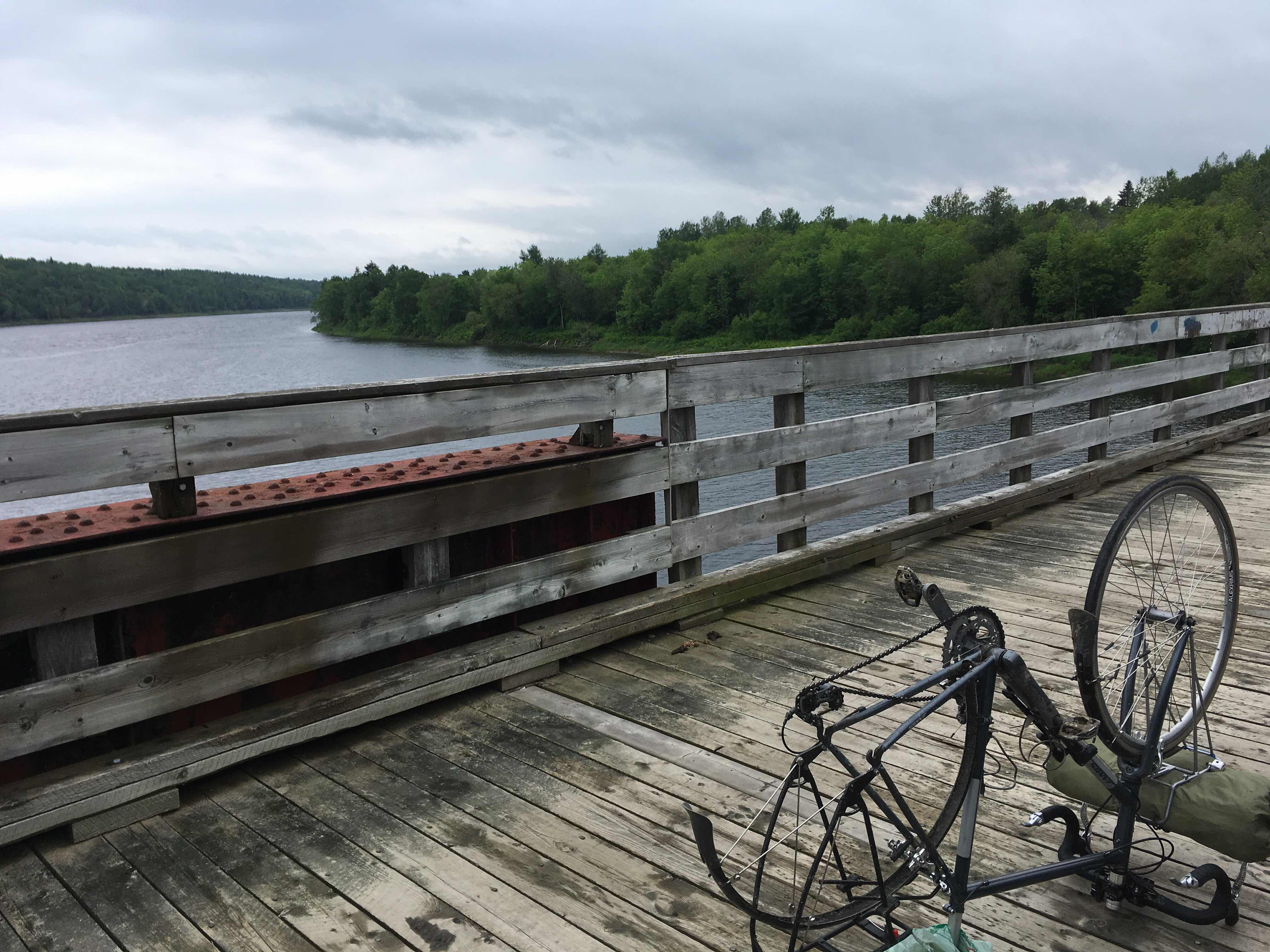
I finally got on the road, a couple hours later than I had wanted, and then just outside Edmundston there was a road closure. I went around the barrier to see if I could climb through it like the day before, but this hole was massive, with diggers, and not traversible. Also, it being Sunday, there weren’t any construction workers there to ask for directions, because, of course, there was no detour signage. I checked my phone, and it looked like the only 2 ways to get around this were: a) detour onto the trans-Canada, which is illegal and dangerous; or b) walk along the train tracks that ran parallel to the road, which is also illegal, but probably slightly less dangerous. And as Zac pointed out to me, every great adventure movie has people walking along train tracks. It was pretty straight in both directions, so I could see from fairly far away if anything was coming, but also for all I knew, these tracks could’ve been decommissioned. There was only one set, and a bit of the way up I could see where there had been the second set of rails, but then it abruptly stopped. 

So anyways, I lugged my loaded up bike onto the tracks and made it the 600 m to bypass the road closure without being smushed by a train. Yay! I also learned that dragging a fully loaded bike across train tracks and rocks is very difficult. A couple hours later I saw the train go by in the opposite direction, so I guess it wasn’t decommissioned after all. 


I kept going along the highway, and I realized that New Brunswick is possibly the most boring place. There’s a bunch of trees, and the views of the St. John river were better than nothing...but the St John is a little underwhelming after biking along the St Lawrence for a week. America is on the other side of the river. That’s about it. That’s all there is to New Brunswick: trees, a dinky river, and a water border with the States. 

As I was getting close to Grand Falls, the signage for the NB trail told me to go off the highway and follow an unpaved path. I followed it, but there was so much gravel I couldn’t even get through, and had to hop off and walk down. Once I was down, the path went for a little and then directed me onto a bridge for the bike path that was closed. With no detour signage. So for the third time, NB completely dropped the ball on this and led me astray. I was starving at this point, so I had a sandwich, and then decided to just stay in Grand Falls for the night. It had been spitting rain all day, but I’d been saved from facing a downpour so far, and I figured if I stayed here I would definitely be able to set up camp without rain. Also, since I had been delayed with the flat and with the train tracks, and also my arch nemesis, headwinds, it was already almost 5, and if I carried on, I figured I’d probably be at the mercy of another cantine rather than having time to cook. 


So I figured out how to get out of that dead end bike pathway, and then as I was on the road into town, I saw Atlantic Superstore. This is my new favourite place in New Brunswick. It’s like No Frills, but better. I had been living off whatever was available in little epiceries for the past week. I got into Atlantic Superstore, and they had hummus and sweet potatoes and ripe avocado and clif bars, and it was heaven. After I had gotten everything to make a bomb dinner, I headed to the Camping Chutes and Gorge, which was a little municipal campsite with views over the gorge. 


The guy who registered me was so friendly and showed me the indoor room where he had a fire going and told me I could add logs to it, and that if it really started coming down and I was cold in my tent, I could just sleep in there during the night. So that was great. Although New Brunswick is super boring, I’ve found all the people to be really nice...

As I was preparing my chilli, I went to one of the RVs to borrow a can opener. It turns out that not having a can opener at a campground is a great way to make friends. The couple I borrowed it from, Anya and Pascal, invited me to join them for a glass of wine around their campfire once I was finished cooking. I took them up on their offer, and it turns out they sold all their stuff in Germany and flew to Halifax and bought a truck and a camper, and are planning to spend the next 2 years in it, going across Canada and then down to Chile. They were super lovely and their adventure sounds so cool! 


Also, I made so much chilli and have a whole Tupperware full for tomorrow, which I’m excited for. 

Total distance: 75 km
Total elevation: 351 m